It is difficult to keep a 412 kilometer-long project a secret. By the fall of 1944 and into 1945, the Allied Air Forces flying out of India and Ceylon (Sri Lanka) were mounting frequent raids on the TBR. Obviously, much of the track was hidden in the jungles, but not so the bridges. Each of these, including the WangPo viaduct were bombed and strafed. Since they were the largest and two structures were side-by-side, the bridges at ThaMarKam were often targeted. Hence we have many recon and post-attack damage assessment aerial photos of this area.
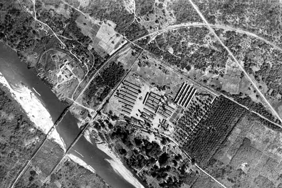
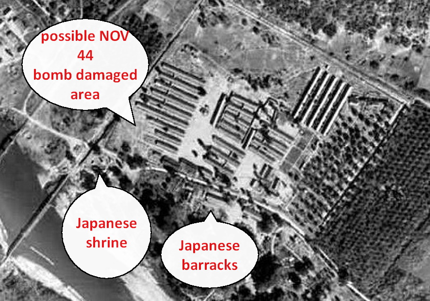
I, personal, enjoy locating any remnants of the TBR that are still recognizable. Of course, there is the iron bridge. But just meters away is the 1944 Japanese shrine to those who died building the railway. It, too, provides a clear landmark to fix other structures around it. It is clear from the above aerial photo that the rails leading to the wooden bridge run just west of it. Deep inside the rather dodgy “museum” nearby are the only remaining remnants of the approach to the wooden bridge.
In the GOOGLE EARTH snap below I have drawn a line running north back towards SangChuto Road. It does appear that the lane (hardly a road) that branches off to the left just after one makes the turn towards the bridge and runs just next to the City Hotel is the actual path of the rails that led to the wooden bridge.
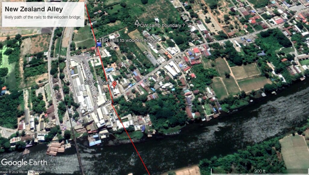
It is reasonably well documented that post-war the Thais simply paved over the rail spur that ran down to the riverside near the walled city. This was built to deliver supplies to the barges that carried them up the Kwae Noi River. So it would be logical that this simple lane –known today as New Zealand Alley – follows the path of rails of that era. It even follows the curve parallel to the existing rails. It is highly unlikely that any of the iron rails would be embedded beneath the roadway.
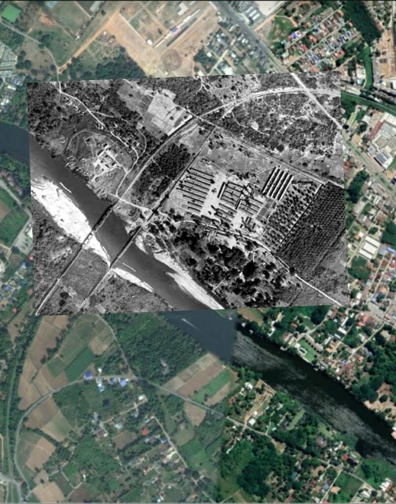
As the second GE overlay above shows that same path of the rails even seems to exist on the far bank of the river, leading directly to the point where the rails merge to head towards ChungKai. There is good evidence that the curving road with the cluster of blue buildings is laid over another rail spur. Although disrupted by farming activity, the embankment for the rails from the wooden bridge can be discerned along the tree line in the above overlay. Unfortunately, as of 2020 that tree line no longer exists to mark the path. Also about that some time, the embankment that marked the point where the wooden bridge met the far bank of the river was bulldozed away to permit expansion of the rather dodgy “POW camp” marketplace. Such is an example of there being no agency or organization within Thailand that strives to preserve remnants of TBR that are still discernable.
This was actually the first Allied POW camp. It was established in NOV 42 when LtCol Toosey’s artillery battalion was transferred here from NongPlaDuk to begin work on the wooden bridge.
The final drawing below quite accurately depicts the ThaMarKam camp which grew over time to include the hospital area buildings set perpendicular to the barracks buildings. Note the 1944 shrine drawn in the upper right corner. While it is clearly visible in the black & white GE overlay above; in the first GE snap it is hidden by large trees directly in front of the City Hotel. It also labels the small structure clearly seen between the rows of barracks as the ‘concert hall’.
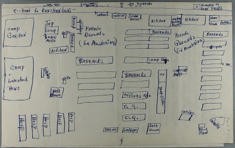
We also know that this area was the home of many of the Dutch and all of the American POWs who were brought from the jungle camps. The British and Australians were at other locations closer to the current war graves cemetery. In NOV 44, some of the bombs aimed at the wooden bridge fell short and killed a number of the Dutch and damaged the shrine that had been dedicated earlier that year. The Japanese housing area — located across the road closer to the river — are harder to locate clustered as they are in the shade of the trees. Few surviving drawings provide us with this much information.
The following is a rather strange compilation of information about the concerts that provided an entertainment outlet for the POWs. It is interspersed with factual data about the POWs and the camps, but provides little useful or new information.
Kanburi-Officers_-CampPDF Embedder requires a url attribute
