Since the mid-1980s the Vajiralongkorn Dam (Khao Laem Dam) has tamed the wild seasonal fluctuations on the Kwae Noi River flowing the length of the Province of Kanchanaburi. A much smaller dam near the town of Tha Muang provides electricity for the region and also helps to provide irrigation water to a spider-web of canals that pervade the eastern end of the province making it a major producer of agricultural products — especially rice and sugar cane.


In the area of the Sai Yok Nat’l Park a major tourist business has arisen with floating bungalows and rafts for rent by Thai day-trippers and foreign tourists alike. A number of small water falls drop directly into the river in that area and there are both small bamboo rafts and entire party/house boats for rent to enjoy lunch and swim in the river.


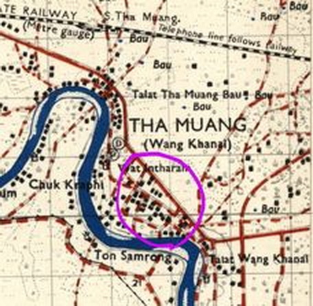
The recent appearance of a period map of the Tha Muang area about 18 Km east of the Bridge suggests that the small hydro-electric dam placed there was actually built on ‘dry land’.

The major bow in the river’s course at that time has been transected by a new channel. This suggests that the late-1960s construction of the dam itself took place in ‘dry land’ then a new channel was cut to provide for the dam runoff. This isolated the former bow in the river and reduced it to more of a side reservoir of irrigation water.

see Section 8.4b for the story of the POW camp that was located near there.
